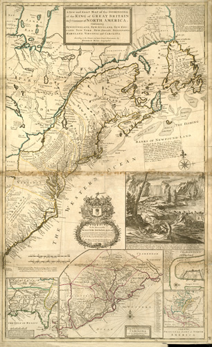
This map by Herman Moll shows North America, specifically what was Newfoundland, New Scotland, New England, New York, New Jersey, Pennsylvania, Maryland, Virginia, and the Carolinas. In the inset in the lower left corner, the map outlines the French territory of Louisiana and the Gulf of Mexico. The inset in the middle shows the settlements of North and South Carolina. On the right, the inset details the town and harbor of Charlestown, an overview of North America, and an illustration of beavers forming dams around Niagara Falls. The map shows vast Native American settlements, the Appalachian Mountains, lakes, waterfalls, counties, rivers, bays, and more. A very detailed map of a vastly-unknown continent in 1755.
Additional information
| Weight | 0.25 lbs |
|---|---|
| Dimensions | 30.37 × 18.56 × 0.002 in |
Map Maker: Moll, Herman
Original Production Year: 1755
Original Production Year: 1755


