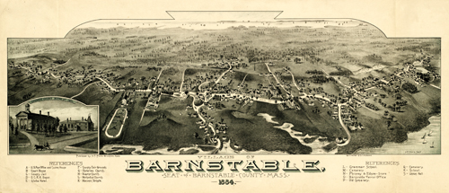
This spectacular map shows the expanse of the village of Barnstable as it was in 1884. This map identifies important rivers, harbors, depots, hotels, churches, cemeteries, streets, stores, and government buildings in the index below. In the inset, the Court House and Jail are illustrated. Numerous residences and railroad lines are included in the map as well. On the horizon, ships sail off. A stunning capture of a very historical town!
Additional information
| Weight | 0.25 lbs |
|---|---|
| Dimensions | 12 × 28 × 0.002 in |
Map Maker: Poole, A. F.
Original Production Year: 1884
Original Production Year: 1884


