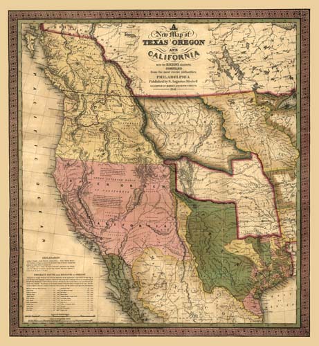
Augustus Mitchell of Philadelphia was one of the most successful and prolific commercial map makers of the middle part of the 19th century. The high regard that his maps held was evidenced by Brigham Young’s desire to obtain a Mitchell map before he led his Mormon followers west to Utah in April, 1847. Seeking the best available maps of the Rocky Mountain area, he wrote to Joseph A. Stratton of St. Louis: “I want you to bring me one half dozen of Mitchell’s new map of Texas, Oregon, and California and the regions adjoining, or his accompaniment to the same for 1846, or rather the latest edition and best map of all the Indian countries in North America; the pocket maps are the best for our use.” The lower left hand corner of the map notes the Emigrant Route from Missouri to Oregon and was certainly of great interest and use to Americans who dreamed of going west. A table notes the reputed distances of the chief points of interest on the route between Westport, Missouri and Oregon City. The flood of American emigrants to the Pacific Northwest, encouraged by what they must have seen and read into Mitchell’s map, assured the United States victory in the demographic contest for the area.
Additional information
| Weight | 0.25 lbs |
|---|---|
| Dimensions | 24 × 21.9 × 0.002 in |
Map Maker: S. Augustus Mitchell
Original Production Year: 1846
Original Production Year: 1846


