 |
||
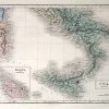
Map of the South Part of Italy
Out of stock
This hand colored, steel engraved map is from Black’s General Atlas printed in 1844. Southern Italy is illustrated on this beautiful map. Details include the names of provinces and important cities, mountain ranges, lakes and rivers, rail lines, and major roads. An inset shows Malta and its dependencies at a larger scale than the main map.
Size: 14.5 x 10 inches
Condition: Excellent
Map Maker: Adam and Charles Black
Coloring: Hand Coloring
Year: 1844
Condition: Excellent
Map Maker: Adam and Charles Black
Coloring: Hand Coloring
Year: 1844
Out of stock