 |
||
North America
Out of stock
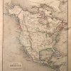
William and Robert Chambers made this map for the “Atlas of Modern and Ancient Geography. For use in schools, and for general reference.” in Edinburgh, 1855. Beautiful, vibrant hand color highlights the boarders of regions on these otherwise black and white maps. North America is illustrated on this small but detailed map. Land boundaries that have since changed, such as New California and Russian America are shown. The names of regions, important cities, rivers, lakes, and mountain ranges are identified.
Size: 8.25 x 10 inches
Condition: Very Good-age toning, very light foxing, light smudge at side
Map Maker: William and Robert Chambers
Coloring: Original Hand Color
Year: 1855
Condition: Very Good-age toning, very light foxing, light smudge at side
Map Maker: William and Robert Chambers
Coloring: Original Hand Color
Year: 1855
Out of stock