 |
||
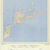
Virgin Gorda, Leeward Islands – British Virgin Islands
Out of stock
Published by Directorate of Overseas Survey in 1959, these detailed topographic map is divided into sheets of the British Virgin Islands. An index to the sheet is on each map for reference. Along with topographic land contour features, other details include roads, buildings, forests, woodlands, plantations, lakes, rivers, and more. This sheet covers Virgin Gorda Island, with Necker, Prickly Pear and Mosquito Islands. Seal Dogs Islands are also shown.
Size: 23.5 x 32 inches
Condition: Very Good, light age toning
Map Maker: Directorate of Overseas Survey
Coloring: Printed Color
Year: 1959
Condition: Very Good, light age toning
Map Maker: Directorate of Overseas Survey
Coloring: Printed Color
Year: 1959
Out of stock