 |
||
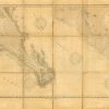
North America – West Coast – West Coast of Mexico and the Gulf of California
Out of stock
This coastal survey was printed by the U.S. Navy Hydrographic Office in Washington D.C. Details include the names of cities and waterways along the coast. Depth soundings are shown in fathoms. Other details that maybe included are lighthouses and buoy positions.
Size: 44 x 26 inches
Condition: Very Good - age toning, foxing, minor staining
Map Maker: Hydrographic Office, U.S. Navy
Coloring: B&W, sectioned and linen-backed, folding map
Year: 1909
Condition: Very Good - age toning, foxing, minor staining
Map Maker: Hydrographic Office, U.S. Navy
Coloring: B&W, sectioned and linen-backed, folding map
Year: 1909
Out of stock