 |
||
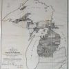
Diagram of the State of Michigan Showing the Districts Embraced in Contracts for Subdivisions North of Grand and Saganaw Rivers.
Out of stock
This black and white survey of part of the state of Michigan was made in 1849 by the Michigan Surveyor General’s Office. The map shows the zoning grids of the state and identifies the progress of the survey in each. The names of some coastal islands and landowners are provided on the map.
Size: 13 x 14.25 inches
Condition: Very Good-age toning, very light foxing, crease across bottom corner
Map Maker: Michigan Surveyor Generals Office'
Coloring: Black and White
Year: 1849
Condition: Very Good-age toning, very light foxing, crease across bottom corner
Map Maker: Michigan Surveyor Generals Office'
Coloring: Black and White
Year: 1849
Out of stock