 |
||
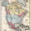
Map of North America
Out of stock
This original hand colored map came from Mitchells New School Atlas, published in 1873. This map details cities and towns, rivers, topography, and existing railroads at the time. Wagon trails and major routes of transport are also shown. On relevant maps native indian tribes are labeled. Notes on the map indicate important explorative routs.
Size: 10.75 x 8.25 inches
Condition: Good with minor staining
Map Maker: S. Augustus Mitchell
Coloring: Original Hand Color
Year: 1873
Condition: Good with minor staining
Map Maker: S. Augustus Mitchell
Coloring: Original Hand Color
Year: 1873
Out of stock