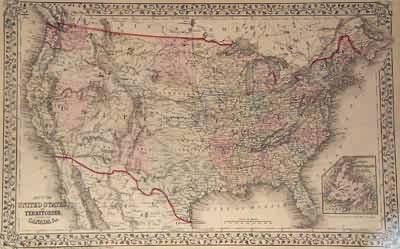
Map of the United States and Territories, Together with Canada
Out of stock
Bound by a decorative ivy border, this map of the United States is illustrated in detailed form with original hand coloring. S. Augustus Mitchell Jr. created this map in 1872. States, important cities, railroads, and topography are identified. Modern day Oklahoma is still Indian Territory, and Dakota has not been split into North and South. Also featured in this fine map is an inset of the Island of Newfoundland.
Size: 21.33 x 13.5 inches
Condition: Very Good-small tears in margin
Map Maker: S. Augustus Mitchell
Coloring: Original Hand Color
Year: 1872
Condition: Very Good-small tears in margin
Map Maker: S. Augustus Mitchell
Coloring: Original Hand Color
Year: 1872
Out of stock


