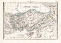
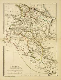
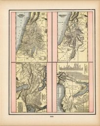
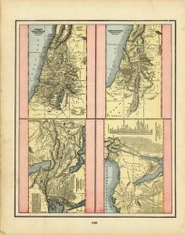
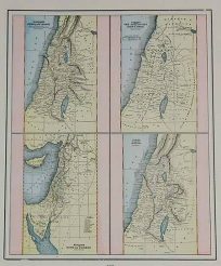
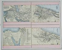
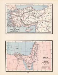
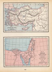
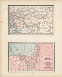
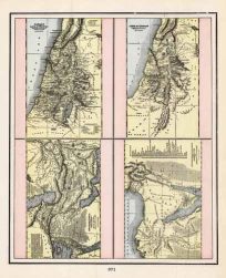
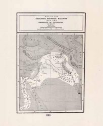
Skip to content
FREE SHIPPING ON ORDERS OVER $85  Facebook Instagram  Twitter
  • Contact Us
  • Newsletter
  • Checkout
  • 44 Item(s) - $8,507.00
    California
    California1 x $150.00
    Chicago
    Chicago1 x $195.00
    Civil War Atlas; Plate 29; Map of the Battles of Harpers Ferry and Sharpsburg; Antietam'
    Civil War Atlas; Plate 29; Map of the Battles of Harpers Ferry and Sharpsburg; Antietam'1 x $225.00
    Civil War Atlas; Plate 95; Map of the Battle-Field of Gettysburg; Cavalry at Gettysburg; Gaps in the Mountains Winters in Tenn. to Louisa in Kentucky
    Civil War Atlas; Plate 95; Map of the Battle-Field of Gettysburg; Cavalry at Gettysburg; Gaps in the Mountains Winters in Tenn. to Louisa in Kentucky1 x $325.00
    Massachusetts. Atlas Plate No. 9.
    Massachusetts. Atlas Plate No. 9.1 x $125.00
    McNally's 1923 Map of New York City1 x $225.00
    Mitchell’s 1846 Map of Texas from the most recent-authorities1 x $950.00
    Western Hemisphere
    Western Hemisphere1 x $200.00
    County Map of California
    County Map of California1 x $265.00
    Eastern Hemisphere
    Eastern Hemisphere1 x $200.00
    Florida1 x $350.00
    Gray's 1876 Geological Map of the United States1 x $100.00
    Map of the United States
    Map of the United States, and Territories1 x $110.00
    Massachusetts. Atlas Plate No. 10.
    Massachusetts. Atlas Plate No. 10.1 x $350.00
    New York and Brooklyn
    New York and Brooklyn1 x $300.00
    Plan of Boston including Charlestown
    Plan of Boston including Charlestown, East Cambridge, East Boston, South Boston with inset map of Boston Harbor1 x $275.00
    Sheet XIII - Central Colorado(Geologic)
    Sheet XIII - Central Colorado(Geologic)1 x $350.00
    American Diner, 1000 Piece Puzzle, White Mountain1 x $22.95
    American Drive-In, 1,000 piece Puzzle1 x $22.95
    Animals of America, 500 Piece Puzzle1 x $24.00
    B. Kliban, Pool Cat, 300 Piece Puzzle1 x $17.95
    Beautiful Boulder 1000 Piece Puzzle1 x $24.95
    Beers of New England, 1,000 Piece Puzzle1 x $22.95
    Best Places in America, 1,000 piece Puzzle1 x $22.95
    Best Sellers Books, 1,000 Piece Puzzle1 x $22.95
    Betty Crocker, 1,000 piece Puzzle1 x $22.95
    Breckenridge, Colorado Ski Resort Trail Map, 1000 pieces1 x $22.95
    Breckenridge, Colorado Town, 1000 pieces1 x $22.95
    Cacti & Succulents Vintage Puzzle, 1000 pieces1 x $21.50
    (Fort Dodge Mil. Res.) Dodge City
    (Fort Dodge Mil. Res.) Dodge City, KS1 x $75.00
    (Paragua or Palawan
    (Paragua or Palawan, Philippines)1 x $50.00
    (Plants and Animals of the World)
    (Plants and Animals of the World)1 x $35.00
    (Polar Views)
    (Polar Views)1 x $35.00
    (U.S. Coast Survey) Petaluma and Napa Creeks
    (U.S. Coast Survey) Petaluma and Napa Creeks1 x $120.00
    (Upper Sheet) U.S. Coast Survey - Sketch A Showing the Progress of the Survey in Section No. I - 1862
    (Upper Sheet) U.S. Coast Survey - Sketch A Showing the Progress of the Survey in Section No. I - 18621 x $40.00
    1328-1453 Europe du Moyan-Age
    1328-1453 Europe du Moyan-Age1 x $50.00
    1453 - 1558 Europe a LEpoque de Charles - Quint (Europe During the Time of Charles - Quint)'
    1453 - 1558 Europe a LEpoque de Charles - Quint (Europe During the Time of Charles - Quint)'1 x $45.00
    Plan of New York City
    Plan of New York City1 x $350.00
    Boston and Adjacent Cities
    Boston and Adjacent Cities1 x $350.00
    Imperii Persici in Omnes suas Provincias.. [Persia]
    Imperii Persici in Omnes suas Provincias.. [Persia]1 x $600.00
    Boston
    Boston1 x $395.00
    Plan of Boston
    Plan of Boston1 x $450.00
    Texas (with inset maps of the Plan of Galveston Bay and Plan of Sabine Lake)1 x $650.00
    Boston and Adjacent Cities
    Boston and Adjacent Cities1 x $295.00
    View Cart
    Checkout
Art Source International Logo Art Source International Logo
  • Home
  • Browse All
    • Christmas & Holiday Gift Ideas for Map & Print Lovers
    • Ancient Maps
      • Browse All
      • Ancient China
      • Ancient Egypt
      • Ancient Greece
      • Ancient India
      • Ancient Israel
    • Original, Antique Maps
      • Browse All
      • Browse by Location
      • City & County Maps
      • Framed Maps
      • Rare Maps
      • Military Maps
      • U.S. Coastal Survey Maps
      • General Land Office
    • Old Map Reproductions
      • Browse All
      • U.S. City Bird’s Eye Views
      • Manuscript Maps
      • War Maps
    • Old World Maps
      • Browse All
      • Original
      • Giclée Reproductions
    • Vintage Prints
      • Browse All
      • By Subject
        • Birds
        • Botanicals
        • Fish
        • More…
      • By Antique Print Makers
        • John James Audobon
        • Picturesque America
        • More…
    • Vintage Posters
      • Collecting Posters
      • Browse All
      • Original
      • Lithograph Reproductions
      • Giclée Reproductions
    • Replogle Globes
      • Browse All
      • Desk Models
      • Floor Models
      • Illuminated
      • 4.7″
      • 12″
      • 16″
      • 20
      • 32
    • Books
      • Browse All
      • Books with Maps
      • Atlases
      • Reference Books
    • Historic Colorado Photos
      • Browse All
      • Boulder
      • Denver
      • Colorado Ski Towns
    • Colorado Art
      • Browse All
      • Kirsten Bingham
      • John Carlson
      • Steve Lowtwait
      • Penny Pearson
  • Puzzles
  • Vintage Maps
  • Old Map Reproductions
  • Vintage Prints
  • Custom Framing
  • Collector’s Guide
    • Time Charts of Historical Cartography
      • Antiquity 600 BC to 300 AD
      • Middle Ages 400 AD to 1400 AD
      • Renaissance 1470 AD to 1700 AD
    • History of Print Making
      • Wood Block
      • Line Engraving
      • Etching
      • Mezzotint Engraving
      • Stipple Engraving
      • Aquatint Engravings
      • Lithographs
      • Color Prints
    • General
      • What Is Meant By The Term “Antique Map”?
      • Condition of Antique Maps
      • Sizes of Antique Maps
      • Coloring of Antique Maps
      • Glossary of Terms
      • Factors Affecting the Value of Maps
      • What Should I Collect?
      • What Should I Pay?
      • The Care of Maps & Prints
      • How to Detect Reproductions?
  • About Us
  • Request Or Sell an Item
    • Request an Item
    • Sell an Item
  • Sort by Default Order
    • Sort by Default Order
    • Sort by Name
    • Sort by Price
    • Sort by Date
    • Sort by Popularity
    • Sort by Rating
  • Show 12 Products
    • Show 12 Products
    • Show 24 Products
    • Show 36 Products
  • Asiae Minoris Tabula Descripta Conatibus (Asia Minor)

    Asiae Minoris Tabula Descripta Conatibus (Asia Minor)

    $75.00
    Only 1 in Stock! Order Now!
    Add to cart Details
  • Assyria

    Assyria

    $50.00
    Only 2 in stock. Order Now!
    Add to cart Details
  • Canaan or the Land of Promise Illustrating the Books of Joshua & Judeas (et.al.)

    Canaan or the Land of Promise Illustrating the Books of Joshua & Judeas (et.al.)

    $35.00
    Only 1 in Stock! Order Now!
    Add to cart Details
  • Earliest Regions B.C. 3000-1000

    Earliest Regions B.C. 3000-1000, and the Birthplace of Civilization

    $65.00
    Add to cart Details
  • Four Maps - Canaan or the Land of Promise Illustrating the Books of Joshua & Judeas (et.al.)

    Four Maps – Canaan or the Land of Promise Illustrating the Books of Joshua & Judeas (et.al.)

    $40.00
    Add to cart Details
  • Four Views of the holy land kingdoms

    Four Views of the holy land kingdoms, Judah Israel, David and Solomon, Judea according to Josephus and Canaan showing The Captivities of Judah and Israel

    $35.00
    Add to cart Details
  • Four Views of the Holy Land

    Four Views of the Holy Land, Mesopotamia Canaan, and Journeyings & Encampment of the Israelites from Eqypt to Canaan

    $35.00
    Add to cart Details
  • Johnsons Turkey in Asia / Johnson’s Persia Arabia Beloochistan and Afghanistan’

    $60.00
    Only 1 in Stock! Order Now!
    Add to cart Details
  • Map of Ancient Asia Minor and Canaan

    Map of Ancient Asia Minor and Canaan

    $35.00
    Add to cart Details
  • Map of Ancient Asia Minor B.C. 650 - A.D. 325 / Canaan Part of Egypt and the Route of the Israelites through the Wilderness B.C. 1652 - 1612

    Map of Ancient Asia Minor B.C. 650 – A.D. 325 / Canaan Part of Egypt and the Route of the Israelites through the Wilderness B.C. 1652 – 1612

    $35.00
    Only 1 in Stock! Order Now!
    Add to cart Details
  • Map of Ancient Asia Minor B.C. 650-A.D. 325 / Map of Canaan

    Map of Ancient Asia Minor B.C. 650-A.D. 325 / Map of Canaan, Part of Egypt and the Routes of the Israelites Throught the Wilderness

    $40.00
    Only 1 in Stock! Order Now!
    Add to cart Details
  • Map of Mesopotamia

    Map of Mesopotamia, Canaan, and Israelites Journey

    $35.00
    Add to cart Details
1 2 Next

Newsletter Signup

Need Help?

Call us toll free at:
800-304-5029
if you can’t find what you’re looking for. We’ll do everything we can to help you track down what you’re looking for!

To browse a list of all categories click here

Contact Us

Mon – Sat: 10am-6pm
Sun: 11am-6pm
Mountain Standard Time

1237 Pearl Street
Boulder, CO 80302
Phone: 800-304-5029

Art Consultant Services

• Digital Files
• Commercial Projects
• Installation

Close
Copyright 2018 Art Source International | All Rights Reserved v 5.3 | All images are copyrighted 2018. No reproduction in any form with out the express written consent of Art Source International Inc.
FacebookInstagramTwitter