 |
||
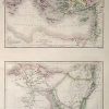
Map of The Countries Embraced Within the Travels of St.Paul – Map of Lower Egypt and the Penninsula of Mt. Sinai and the Journeys of the Israelites
Out of stock
This hand colored, steel engraved map is from Black’s General Atlas printed in 1844. Details on these beautiful maps of the countries explored by St. Paul and Lower Egypt with the Penninsula of Mt.Sinai include the names of regions and important cities, illustrations of rivers, lakes and mountains. The top map, Travels of St. Paul, illustrates the routes by boat and land taken by St. Paul. The bottom map shows Lower Egypt and the probable route taken by the Israelites from Kadesh and then their return.
Size: 10.5 x 16 inches
Condition: Excellent
Map Maker: Adam and Charles Black
Coloring: Hand Coloring
Year: 1844
Condition: Excellent
Map Maker: Adam and Charles Black
Coloring: Hand Coloring
Year: 1844
Out of stock