 |
||
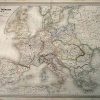
Carte de LEmpire Francais 1812′
Out of stock
This large, steel engraved, hand colored map was made for the “Atlas Universel” by H. Dufour in 1864. France as divided in 1812 is illustrated on this French map. Beautiful pastel coloring distinguishes regions. The names of regions, and important cities, rivers, lakes, mountain ranges, major roads, and railroad lines are identified.
Size: 29.5 x 22 inches
Condition: Very Good-age toning, water staining in margin
Map Maker: H. Dufour
Coloring: Original Hand Color
Year: 1864
Condition: Very Good-age toning, water staining in margin
Map Maker: H. Dufour
Coloring: Original Hand Color
Year: 1864
Out of stock