 |
||
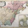
Carte Generale du Canada, de la Louisiane, de la Floride, de la Caroline, de la Virginie, de la Nouvelle Angeleterre
Out of stock
This hand colored French map was made in 1776 by D”Anville. The United States and Canada are illustrated on this exceptional map showing the boarders of states and territories at this important time. An inset shows the Hudson River Valley at a greater scale than the main map. All titles and notes are in French. The names of regions and important cities are provided. Illustrations of rivers, lakes, and mountains are included as well.
Size: 26 x 19 inches
Condition: Very Good-age toning
Map Maker: DAnville'
Coloring: Original Hand Color
Year: 1776
Condition: Very Good-age toning
Map Maker: DAnville'
Coloring: Original Hand Color
Year: 1776
Out of stock