- You cannot add another "Counties of Northampton, Carbon, Monroe, and Lehigh (Pennsylvania)" to your cart. View cart
 |
||
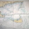
Massachusetts- Nantucket Sound and Approaches
Out of stock
This coastal survey was made in Washington D.C. on December 23, 1944 by the U.S. Coast and Geodetic Survey. Nantucket Sound and approaches and the Massachusetts coast are illustrated on this map. Details include the names of islands, water ways and important cities on the coast, depth readings, identification of radio beacons, bouys, and lights (stamped on map), cable lines, and restricted and prohibited areas where appropriate. The most recent corrections are stamped on the map. Notes on the map include: Warning: Aids to navigation may be altered, interrupted or removed without notice. In general, temporary changes due to war conditions are not incorporated on the chart. Explainations of Rules of the road for inland waters” and local tidal currents are also given.
Condition: Excellent
Map Maker: U.S. Coast and Geodetic Survey
Coloring: Machine Color
Year: 1944
Out of stock