Arkansas
In stock
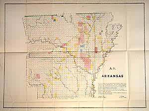
The 1850 GLO uses shaded and outline color in blue, pink, green and yellow to show survey areas in different stages of completion. Western border of the state is marked by Choctaw and Cherokee boundary lines, and Texas border appears in southwest. Towns marked include Little Rock, Pine Bluff, Fayetteville, Hot Springs, Columbia, Batesville, Van Buren and Fulton. Other features of interest: the Old Cherokee Line running between the Arkansas and White Rivers and a very small Cherokee reservation on the Arkansas.
Size: 21.5 x 16 inches
Condition: Very Good
Map Maker: General Land Office
Coloring: Original Outline Color
Year: 1850
Condition: Very Good
Map Maker: General Land Office
Coloring: Original Outline Color
Year: 1850
In stock


