 |
||
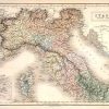
Italy, North Part
Out of stock
This hand colored map was made by Adam and Charles Black in 1851 for “Black’s General Atlas”. Northern Italy is illustrated on this map. An inset shows the environs of Rome. Regions are distinguished by pink,orange,green,blue and yellow color. Other details include the names of regions and many cities, lakes,mountains, and rivers. The impression of the press used to engrave the map is still evident.
Size: 14.5 x 10 inches
Condition: Very Good-age toning
Map Maker: Adam and Charles Black
Coloring: Original Hand Color
Year: 1851
Condition: Very Good-age toning
Map Maker: Adam and Charles Black
Coloring: Original Hand Color
Year: 1851
Out of stock