 |
||
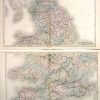
Map of England and Wales, set of two
Out of stock
These hand colored, steel engraved, maps are from Black’s General Atlas printed in 1844. England and Wales are illustrated on these two (top and bottom half) maps. Details, exceptional a map from this time, include county and city names, lakes, rivers and mountains, rail lines, and important roads. An inset on the bottom map illustrates the Scilly Isles at the same scale as the main map.
Size: 21.5 x 16.25 inches
Condition: Excellent-aging at fold
Map Maker: Adam and Charles Black
Coloring: Hand Coloring
Year: 1844
Condition: Excellent-aging at fold
Map Maker: Adam and Charles Black
Coloring: Hand Coloring
Year: 1844
Out of stock