 |
||
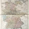
Map of Germany
Out of stock
This hand colored, steel engraved map is from Black’s General Atlas printed in 1844. This beautiful map of Germany shows details including the names of kingdoms and important cities, mountain ranges, rivers, lakes, major roads, and rail lines. All kingdoms are identified by Roman Numerals which are explained in a key at the bottom of the page.
Size: 14.5 x 19 inches
Condition: Excellent
Map Maker: Adam and Charles Black
Coloring: Hand Coloring
Year: 1844
Condition: Excellent
Map Maker: Adam and Charles Black
Coloring: Hand Coloring
Year: 1844
Out of stock