|
||
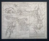
Carte de la Californie et des Pays Nord-Ouest separes de lAsie’
Out of stock
This map illustrating western North America was made by Vaugondy for Diderot in 1772. The map shows the western coast from 70 degrees longitude through the Tropic of Cancer with identification of important places in French. A large inset contains a smaller image of the main map and includes rivers and lakes further inland. This rare and fabulously well maintained map is in excellent condition; still bearing the indentations from the original copper plate engraving and beautiful coloring as issued.
Condition: Excellent-age toning, very light off-setting
Map Maker: Robert de Vaugondy
Coloring: Original Hand Color
Year: 1772
Map Maker: Robert de Vaugondy
Coloring: Original Hand Color
Year: 1772
Out of stock