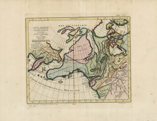
Carte Generale des Decouvertes (NORTH AMERICA, SIBERIA, RUSSIA)
In stock
The Carte Générale des Découvertes de l’Amiral de Fonte is an 18th-century map based on a mythical 17th-century voyage by Admiral Bartholomew de Fonte, who supposedly sailed from Peru and discovered a water route connecting the Pacific Ocean to Hudson Bay. First published in 1708, the story described a series of lakes and rivers—including fictional features like Lake de Fonte and the Rio de los Reyes—that formed an inland passage across North America. Though widely believed for a time and featured on maps by prominent cartographers like Delisle and Buache, de Fonte’s voyage was eventually discredited as later explorations, particularly by Cook and Vancouver, revealed no such route. Today, the map is considered a historical example of geographic myth and the speculative nature of early exploration.
Condition: Excellent
Map Maker: Denis Diderot
Coloring: Original Hand Coloring
Year: 1772
In stock


