|
||
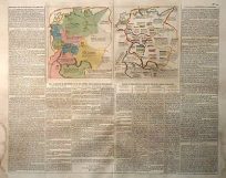
Carte Geographique, Statistique Et Historique Du Perou ( PERU)
Out of stock
This map was published in Paris for Buchon’s 1825 Atlas Geographique, Statistique, Historique et Chronologique des Deux-Ameriques et des iles adjacents. This map is double page hand-colored engraved. The central map image of Peru is surrounded by letterpress explanatory text ( in French), which includes details of climate, topography, commerce, religion, government, governors, basic history and important military engagements are discussed. This is a fine map and is a great example of a superior 18th century engraving technique.
Condition: Very Good
Map Maker: Jean-Alexander Buchon
Coloring: Original Hand Coloring
Year: 1825
Map Maker: Jean-Alexander Buchon
Coloring: Original Hand Coloring
Year: 1825
Out of stock