|
||
Tabula Italia Antiqua Geographica
Out of stock
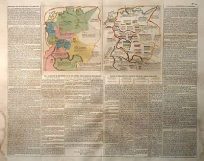
This map of Italy was made in 1764 by D”Anville. The names of provinces and important cities are in Latin with some sub-titles in English. Two insets show the environs of Rome and Urbs Septicollis at a greater scale. The majority of the map is black and white, regions are outlined with pastel color.
Condition: Good-age toning, light foxing and water stains, minor paper loss
Map Maker: DAnville'
Coloring: Original Hand Color
Year: 1764
Map Maker: DAnville'
Coloring: Original Hand Color
Year: 1764
Out of stock