|
||
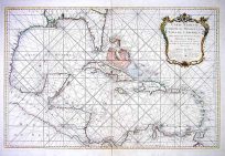
Venezuela cum parte Australi Novae Andalusiae
Out of stock
Art Source International is proud to offer rare maps produced in 1633 by one of the dominant map-making houses of the 1630s. The atlas that this map is attributed to was first published in 1633 by Henricus Hondius and Joannes Janssonius and contained individual works by each map-maker, some derived from Henricus’s brother Jodocus” plates, and a number of maps by Mercator that Hondius acquired from his father -also Jodocus. Although it is somewhat unclear which maps were published cooperatively between Henricus Hondius and Joannes Janssonius and which were individual works, this map of Venezuela bears the imprint of Henricus Hondius. The large, exceptionally well maintained map has beautiful hand coloring highlighting rivers, coast lines, and political boundaries. Many place names are identified, especially along the coast. The map is very full and colorful with two compass roses and a ship in the ocean.
Map Maker: Henricus Hondius
Coloring: Hand Color
Year: circa 1633
Out of stock