- You cannot add another "Climatological Map of Pennsylvania Showing the Average Temperture & Amount of Rainfall" to your cart. View cart
 |
||
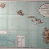
Territory of Hawaii
Out of stock
This map of the Islands of Hawaii was made by the US Coast and Survey-Department of the Interior in 1920. The names of islands, counties, and important cities, as well as rail lines, national parks, the previous paths of lava and the date of the erruption, and craters and mountains are identified.An inset is included of the Hawaiian Archipelago and the bird reservation. A chart shows the distance from Honolulu to major cities in the Pacific Ocean.
Size: 33 x 21.5 inches
Condition: Very Good- age toning, minor paper loss at folds
Map Maker: General Land Office
Coloring: Machine Color
Year: 1920
Condition: Very Good- age toning, minor paper loss at folds
Map Maker: General Land Office
Coloring: Machine Color
Year: 1920
Out of stock