 |
||
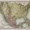
Vereinigtestaten von Nord-America und Mexico ( UNITED STATES AND MEXICO)
Out of stock
This unique map of the United States and Mexico was made by Meyer, a German map maker. States, Native American territories, cities, towns, topographical freatures, and transportation routes are illustrated. The very rare stave-pipe configuration of Texas is depicted and a legend listing the capitals of states is included. A great map!
Size: 10 x 7.5 inches
Condition: Excellent
Map Maker: Meyer
Coloring: Hand Colored
Year: 1850
Condition: Excellent
Map Maker: Meyer
Coloring: Hand Colored
Year: 1850
Out of stock