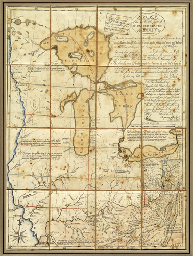
This 1785 map by John Fitch, inventor, entrepreneuter, and engineer, shows what is present-day Ohio, Kentucky, Michigan, and Canada. The map shows Kentucky Country,” but it doesn’t name Ohio, Indiana, Pennsylvania, or Michigan. The map does show the Great Lakes, the Mississippi River, the Illinois River, the Ohio River, and more. Longitude and latitude lines are also displayed.In his own notes, Fitch writes that his map isn’t exact to the areas he covered, that it’s only a general sketch, but he had hoped to have made improvements from previous maps of this region. Fitch pays his respects to mapmaker Thomas Hutchin by writing, “I beg to lay at your feet avery humble attempt to promote a Science of which you are so bright an ornament… I could not render it as pleasing to the eye as I would have wished.” The map contains his other notes of the area.Fitch created this map in “his leisure hours” to help spur funding for his steamboat business. As he was one of the first in the United States to get the steamboat going, and this shortly after the Revolutionary war, Fitch spent his whole life trying to promote and patent the steamboat. While his structures were mechanically sound, and he gained a patent over them, he wasn’t able to secure the monopoly needed to ensure investors’ support in the United States. He then took his plans to France, but France was torn by war during this time, and he wasn’t able to carry them out.”
Additional information
| Weight | 0.25 lbs |
|---|---|
| Dimensions | 30 × 23 × 0.002 in |
Map Maker: John Fitch
Original Production Year: 1785
Original Production Year: 1785


