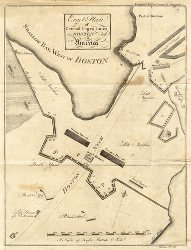
This 1775 map by Aitken shows one of the earliest battle plans of the American Revolutionary War.It shows American lines during the Siege of Boston, the guard house, the bomb battery, the blockhouse, and the citadel. The Siege of Boston happened shortly after the Battles of Lexington and Concord; the siege resulted in the British abandoning Boston via sea, after 11 months, for Nova Scotia. Cartographic elements include a compass and scale.
Additional information
| Weight | 0.25 lbs |
|---|---|
| Dimensions | 12 × 9 × 0.002 in |
Map Maker: Robert Aitken
Original Production Year: 1775
Original Production Year: 1775


