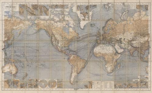
This pocket map, chart of the world on Mercator’s projection by Hermann Berghaus shows routes of steam navigation companies, lines of steam packet communications, telegraph lines, tracks of sailing vessels, ocean depths and currents. There are multiple insets around the map, including wind charts, ports, cities, declination lines, polar projections and much more. The first edition of this map was done in 1863, and this copy being the 9th edition. This map is extremely unique in it’s coloring and detail. This is one of the most detailed world maps we’ve come across.
Additional information
| Weight | 0.25 lbs |
|---|---|
| Dimensions | 22 × 36 × 0.002 in |
Map Maker: Hermann Berghaus
Original Production Year: 1879
Original Production Year: 1879


