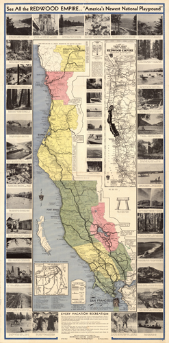
This piece depicts the Redwood Empire. The map contains photographs of things to do around the Redwood Emire: fishing, hunting, gold mining, boating, mineral springs, golfing, rodeo, and more. It also features attractions in San Francisco including Fisherman’s Wharf, Golden Gate Park, Chinatown, Mills Field Airport, and the Palace of Fine Arts. The map shows ferries and railroads interspersed throughout the west coast. Indian reservations are also depicted. Also shown is the average summer temperature and mean summer rainfall. The map goes as far north as Vancouver and as far south as San Francisco Bay.
Additional information
| Weight | 0.25 lbs |
|---|---|
| Dimensions | 24 × 11 × 0.002 in |
Map Maker: Redwood Empire Association
Original Production Year: 1940
Original Production Year: 1940


