 |
||
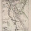
Map of Egypt and Arabia Petraea
Out of stock
This hand colored, steel engraved map is from Black’s General Atlas printed in 1844. Egypt and Arabia Patraea are illustrated on this map. An explaination of the vehicle for travel used extensively in Egypt at this time is given as well as translation of terms used on the map from Arabic to English. Insets show the main pyramids, the ruins of Petra and Thebes. Details include the names of provinces and important cities, mountain ranges, lakes and rivers,deserts, and major roads.
Size: 10 x 14.75 inches
Condition: Excellent
Map Maker: Adam and Charles Black
Coloring: Hand Coloring
Year: 1844
Condition: Excellent
Map Maker: Adam and Charles Black
Coloring: Hand Coloring
Year: 1844
Out of stock