 |
||
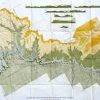
Geological Map and Sections of Book Cliffs Coal Field, Colorado
Out of stock
This map shows the geological features and topography of Book Cliffs Coal Fields in Colorado. Made for the U.S. Geological Survey ca.1930, this map has details including the names of counties and towns, rivers, lakes, and other important landforms.
Size: 50 x 24 inches
Condition: Very Good- age toning
Map Maker: U.S. Geological Survey
Coloring: Machine Color
Year: circa 1930
Condition: Very Good- age toning
Map Maker: U.S. Geological Survey
Coloring: Machine Color
Year: circa 1930
Out of stock