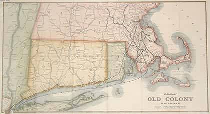
Map of the Old Colony Railroad and Connections
Out of stock
This map depicting Old Colony railroad and Conections is very well done. This map, dated 1893 would have been produced by the railroad. It is done in brilliant pastel colors and would make a wonderful addition to any map collection for its unique and one of a kind depiction of the Old Colony.
Size: 17 x 9.5 inches
Condition: Very Good
Map Maker: H.F Walling
Coloring: Original Hand Coloring
Year: 1893
Condition: Very Good
Map Maker: H.F Walling
Coloring: Original Hand Coloring
Year: 1893
Out of stock


