Skip to content
FREE SHIPPING ON ORDERS OVER $100
Facebook
Instagram
Twitter
Contact Us
Checkout
47 Item(s)
-
$
6,227.00
Larus Fuscus, Linn. (Lesser Black-Backed Gull)
1 x
$
500.00
European Russia
1 x
$
70.00
Hillsborough Bridge P.O. (New Hampshire)
1 x
$
50.00
Counties of Erie, Crawford & Venango (Pennsylvania)
1 x
$
50.00
Eastern Half of Virginia and West Virginia
1 x
$
60.00
Mile High Lakes Quadrangle, Colorado
1 x
$
35.00
County Map of the State of New Jersey
1 x
$
55.00
Counties of Fayette, Effingham, Clay, and Marion, Illinois
1 x
$
75.00
Counties of Wayne and Pike (Pennsylvania)
1 x
$
55.00
Counties of Allegheny, Washington, and Greene (Pennsylvania)
1 x
$
55.00
Massachusetts-Provincetown Sheet
1 x
$
140.00
Counties of Northampton, Carbon, Monroe, and Lehigh (Pennsylvania)
1 x
$
55.00
Counties of Clinton & Centre (Pennsylvania)
1 x
$
55.00
Sesquicentennial Map of Texas 1836-1986 (Texas Revolution 1835-1836)
5 x
$
125.00
Gulf of Venezuela, Peninsula de Guajira, Castilletes Anchorage and Approaches
1 x
$
65.00
Climatological Map of Pennsylvania Showing the Average Temperture & Amount of Rainfall
1 x
$
32.00
Counties of Clearfield, Cambria and Blair (Pennsylvania)
1 x
$
55.00
Outline Plan of Monroe County, Mich.
1 x
$
75.00
Counties of Madison, Bond, and Clinton, Illinois
1 x
$
75.00
Counties of Warren, McKean, Potter, Forest, Elk and Cameron (Pennsylvania)
1 x
$
55.00
County Map of Oregon, Washington, Territory of Alaska
1 x
$
145.00
Counties of Jefferson, Clarion, Indiana, and Armstrong (Pennsylvania)
1 x
$
55.00
Nouvelle Representation Des Cotes Nord et Elt DelAsie (NORTHEAST ASIA)'
1 x
$
250.00
Commemorative Map of the Republic of Texas
4 x
$
50.00
Views in Third Congressional District - Schori & Lehmann Brewery in Elgin, Court House in West Union and Residence of Hon. P.G. Baily in Grand Meadow
1 x
$
60.00
County Map of Oregon and Washington/Territory of Alaska
1 x
$
145.00
Noddy Tern
1 x
$
165.00
Bewick's Wren
1 x
$
175.00
Counties of Sangamon, Macoupin, and Montgomery, Illinois
1 x
$
75.00
1866 Coastal Chart of Portsmouth Harbor, New Hampshire
1 x
$
85.00
1866 Coastal Chart of Warren, Rhode Island
1 x
$
95.00
Revolutionary War Map of part of Rhode Island showing the Positions of the American and British Armies at the Siege of Newport and the subsequent Action on the 29th of August 1773(1850)
1 x
$
165.00
Revolutionary War Map Showing New York City
1 x
$
175.00
The Obelisk
1 x
$
1,725.00
Royal Tern
1 x
$
200.00
Sesquicentennial Map of Texas 1836-1986 (Texas Revolution 1835-1836)
2 x
$
50.00
(Upper Sheet) U.S. Coast Survey - Sketch A Showing the Progress of the Survey in Section No. I - 1864
1 x
$
50.00
Bradfield Canal (Alaska)
1 x
$
50.00
Counties of St. Clair, Monroe, Randolph, Perry, and Washington, Illinois
1 x
$
75.00
View Cart
Checkout
Search for:
Search for:
Home
Browse All
Christmas & Holiday Gift Ideas for Map & Print Lovers
Ancient Maps
Browse All
Ancient China
Ancient Egypt
Ancient Greece
Ancient India
Ancient Israel
Original, Antique Maps
Browse All
Browse by Location
City & County Maps
Framed Maps
Rare Maps
Military Maps
U.S. Coastal Survey Maps
General Land Office
Old Map Reproductions
Browse All
U.S. City Bird’s Eye Views
Manuscript Maps
War Maps
Old World Maps
Browse All
Original
Giclée Reproductions
Vintage Prints
Browse All
By Subject
Birds
Botanicals
Fish
More…
By Antique Print Makers
John James Audobon
Picturesque America
More…
Vintage Posters
Collecting Posters
Browse All
Original
Lithograph Reproductions
Giclée Reproductions
Replogle Globes
Browse All
Desk Models
Floor Models
Illuminated
4.7″
12″
16″
20
32
Books
Browse All
Books with Maps
Atlases
Reference Books
Historic Colorado Photos
Browse All
Boulder
Denver
Colorado Ski Towns
Colorado Art
Browse All
Kirsten Bingham
John Carlson
Steve Lowtwait
Penny Pearson
Puzzles
Vintage Maps
Old Map Reproductions
Vintage Prints
Custom Framing
Collector’s Guide
Time Charts of Historical Cartography
Antiquity 600 BC to 300 AD
Middle Ages 400 AD to 1400 AD
Renaissance 1470 AD to 1700 AD
History of Print Making
Wood Block
Line Engraving
Etching
Mezzotint Engraving
Stipple Engraving
Aquatint Engravings
Lithographs
Color Prints
General
What Is Meant By The Term “Antique Map”?
Condition of Antique Maps
Sizes of Antique Maps
Coloring of Antique Maps
Glossary of Terms
Factors Affecting the Value of Maps
What Should I Collect?
What Should I Pay?
The Care of Maps & Prints
How to Detect Reproductions?
About Us
Request Or Sell an Item
Request an Item
Sell an Item
Search for:
Revolutionary War
Default sorting
Sort by popularity
Sort by latest
Sort by price: low to high
Sort by price: high to low
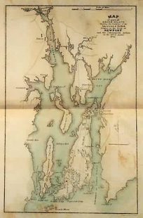
Revolutionary War Map Showing part of Rhode Island
$
125.00
Only 1 in Stock! Order Now!
Add to cart
Details
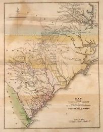
Revolutionary War Map Showing parts of Virginia, North Carolina, South Carolina and Georgia
$
135.00
Only 1 in Stock! Order Now!
Add to cart
Details
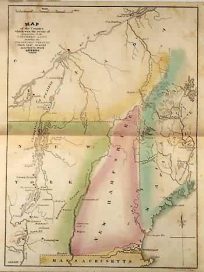
Revolutionary War Map Showing Quebec and Northern New York State
$
125.00
Only 1 in Stock! Order Now!
Add to cart
Details
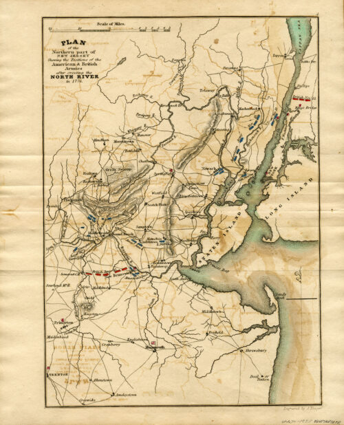
Revolutionary War Map showing the Plan of the Northern part of New Jersey showing the Positions of the American and British Armies after crossing the North River in 1776, (1835)
$
150.00
Only 1 in Stock! Order Now!
Add to cart
Details
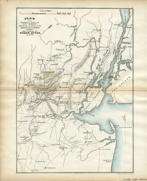
Revolutionary War Map showing the Plan of the Northern part of New Jersey showing the Positions of the American and British Armies after crossing the North River in 1776, (1850)
$
150.00
Only 1 in Stock! Order Now!
Add to cart
Details
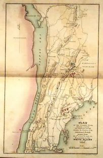
Revolutionary War Map Showing White Plains, New York
$
125.00
Only 1 in Stock! Order Now!
Add to cart
Details
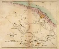
Revolutionary War Map Showing York, Virginia
$
125.00
Only 1 in Stock! Order Now!
Add to cart
Details
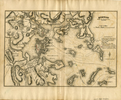
Revolutionary War Map, Boston with its Environs,1776, (1835)
$
195.00
Only 1 in Stock! Order Now!
Add to cart
Details
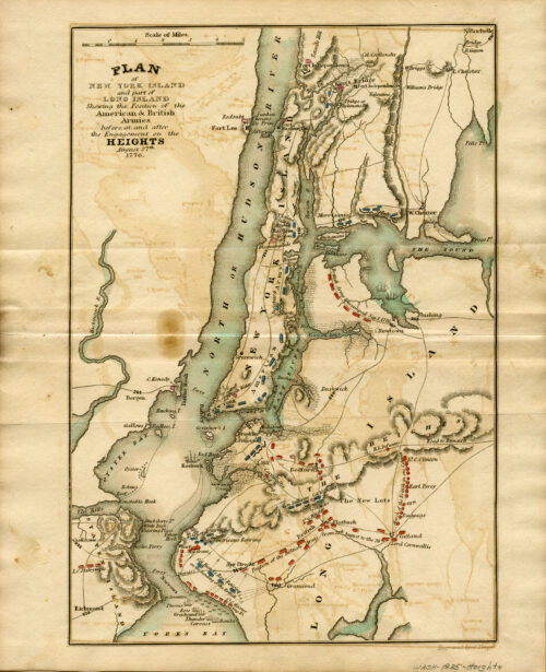
Revolutionary War Map, Plan of New York Island(City) and part of Long Island showing the position of the American and British Armies before and after the Engagement on the Heights, August 27th, 1776 , (1835)
$
195.00
Only 1 in Stock! Order Now!
Add to cart
Details
Revolutionary War Map, Plan of New York Island(City) and part of Long Island showing the position of the American and British Armies before and after the Engagement on the Heights, August 27th, 1776 , 1850
$
195.00
Only 1 in Stock! Order Now!
Add to cart
Details
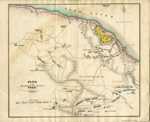
Revolutionary War Map, Plan of the Investment and Attack of York (Yorktown) in Virginia, 1781, (1835)
$
175.00
Only 1 in Stock! Order Now!
Add to cart
Details
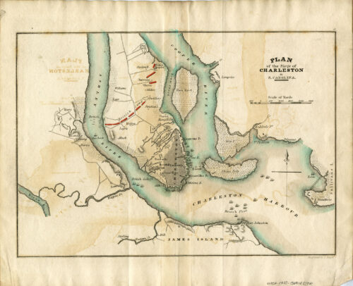
Revolutionary War Map, Plan of the Siege of Charleston, South Carolina(1776), (1835)
$
195.00
Only 1 in Stock! Order Now!
Add to cart
Details
Previous
1
2
Page load link
Go to Top