Skip to content
FREE SHIPPING ON ORDERS OVER $100
Facebook
Instagram
Twitter
Contact Us
Checkout
44 Item(s)
-
$
18,839.25
Sesquicentennial Map of Texas 1836-1986 (Texas Revolution 1835-1836)
4 x
$
50.00
Climatological Map of Pennsylvania Showing the Average Temperture & Amount of Rainfall
1 x
$
32.00
Counties of Allegheny, Washington, and Greene (Pennsylvania)
1 x
$
55.00
Mile High Lakes Quadrangle, Colorado
1 x
$
35.00
Hillsborough Bridge P.O. (New Hampshire)
1 x
$
50.00
Massachusetts-Provincetown Sheet
1 x
$
140.00
Counties of Wayne and Pike (Pennsylvania)
1 x
$
55.00
Counties of Clinton & Centre (Pennsylvania)
1 x
$
55.00
County Map of the State of New Jersey
1 x
$
55.00
Colorado Fourteeners, the Mountains Above 14,000 Feet
1 x
$
40.00
Commemorative Map of the Republic of Texas
4 x
$
50.00
Gore Range and Eagle's Nest Wilderness from Eagle's Nest Restaurant - Vail, Colorado
1 x
$
25.00
Gulf of Venezuela, Peninsula de Guajira, Castilletes Anchorage and Approaches
1 x
$
65.00
Counties of Jefferson, Clarion, Indiana, and Armstrong (Pennsylvania)
1 x
$
55.00
Outline Plan of Monroe County, Mich.
1 x
$
75.00
Counties of Platt, Champaign, and Vermillion, Illinois
1 x
$
75.00
Birds-Eye-View of the Holy Land
1 x
$
45.00
Sesquicentennial Map of Texas 1836-1986 (Texas Revolution 1835-1836)
3 x
$
125.00
Counties of Northampton, Carbon, Monroe, and Lehigh (Pennsylvania)
1 x
$
55.00
J.H. Colton's 1855 Map of Mexico
1 x
$
250.00
Counties of Fayette, Effingham, Clay, and Marion, Illinois
1 x
$
75.00
European Russia
1 x
$
70.00
Counties of Clearfield, Cambria and Blair (Pennsylvania)
1 x
$
55.00
View Looking South from Montrose, Colorado
1 x
$
25.00
Counties of Madison, Bond, and Clinton, Illinois
1 x
$
75.00
Counties of Erie, Crawford & Venango (Pennsylvania)
1 x
$
50.00
Birds-Eye-View of the Holy Land
1 x
$
40.00
The Executive
1 x
$
111.25
Bath, Ernesttown - Yarker, Camden - Parham, Hinchinbrooke - Violet, Ernesttown, Ontario, Canada
1 x
$
75.00
Counties of Warren, McKean, Potter, Forest, Elk and Cameron (Pennsylvania)
1 x
$
55.00
The Diplomat
1 x
$
15,985.00
San Juan Mountains/Weminuche Wilderness From Pagosa Springs, Colorado
1 x
$
25.00
Counties of St. Clair, Monroe, Randolph, Perry, and Washington, Illinois
1 x
$
75.00
Johnsons Mexico - Johnson's Central America'
1 x
$
75.00
Counties of Whiteside, Henry, and Bureau, Illinois
1 x
$
75.00
Periodic Table of the Fifty-Something Colorado Fourteeners
1 x
$
36.00
View Cart
Checkout
Search for:
Search for:
Home
Browse All
Christmas & Holiday Gift Ideas for Map & Print Lovers
Ancient Maps
Browse All
Ancient China
Ancient Egypt
Ancient Greece
Ancient India
Ancient Israel
Original, Antique Maps
Browse All
Browse by Location
City & County Maps
Framed Maps
Rare Maps
Military Maps
U.S. Coastal Survey Maps
General Land Office
Old Map Reproductions
Browse All
U.S. City Bird’s Eye Views
Manuscript Maps
War Maps
Old World Maps
Browse All
Original
Giclée Reproductions
Vintage Prints
Browse All
By Subject
Birds
Botanicals
Fish
More…
By Antique Print Makers
John James Audobon
Picturesque America
More…
Vintage Posters
Collecting Posters
Browse All
Original
Lithograph Reproductions
Giclée Reproductions
Replogle Globes
Browse All
Desk Models
Floor Models
Illuminated
4.7″
12″
16″
20
32
Books
Browse All
Books with Maps
Atlases
Reference Books
Historic Colorado Photos
Browse All
Boulder
Denver
Colorado Ski Towns
Colorado Art
Browse All
Kirsten Bingham
John Carlson
Steve Lowtwait
Penny Pearson
Puzzles
Vintage Maps
Old Map Reproductions
Vintage Prints
Custom Framing
Collector’s Guide
Time Charts of Historical Cartography
Antiquity 600 BC to 300 AD
Middle Ages 400 AD to 1400 AD
Renaissance 1470 AD to 1700 AD
History of Print Making
Wood Block
Line Engraving
Etching
Mezzotint Engraving
Stipple Engraving
Aquatint Engravings
Lithographs
Color Prints
General
What Is Meant By The Term “Antique Map”?
Condition of Antique Maps
Sizes of Antique Maps
Coloring of Antique Maps
Glossary of Terms
Factors Affecting the Value of Maps
What Should I Collect?
What Should I Pay?
The Care of Maps & Prints
How to Detect Reproductions?
About Us
Request Or Sell an Item
Request an Item
Sell an Item
Search for:
Vintage Antique Texas
“Commemorative Map of the Republic of Texas” has been added to your cart.
Continue shopping
Default sorting
Sort by popularity
Sort by latest
Sort by price: low to high
Sort by price: high to low
Sale!
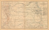
Civil War Atlas: Plate 159; Parts of Indian Territory, Arkansas and Texas
$
75.00
Original price was: $75.00.
$
60.00
Current price is: $60.00.
Add to cart
Details
Sale!
Civil War Atlas: Plate 160; Parts of Kansas, Indian Territory, Arkansas and Texas
$
75.00
Original price was: $75.00.
$
60.00
Current price is: $60.00.
Add to cart
Details
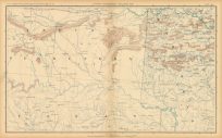
Civil War Atlas; Plate 119; Map of the States of Kansas, Texas, Indian Territory and parts of Colorado and New Mexico
$
150.00
Only 1 in Stock! Order Now!
Add to cart
Details
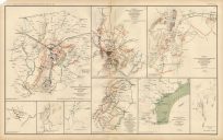
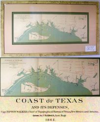
Civil War Atlas; Plate 43; Map of Battles Gettysburg and Winchester; Map of Texas Coast
$
295.00
Only 2 in stock. Order Now!
Add to cart
Details
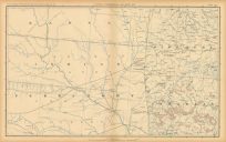
Civil War Atlas; Plate 54; Map of Texas and Part of New Mexico
$
375.00
Add to cart
Details
Sale!
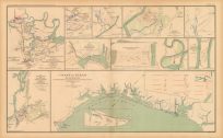
Civil War Atlas; Plate 65; Coast of Texas; Bermuda Hundred
$
75.00
Original price was: $75.00.
$
60.00
Current price is: $60.00.
Add to cart
Details
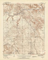
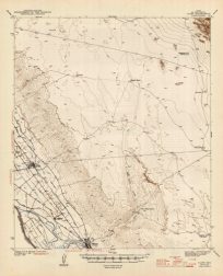
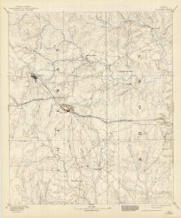
CLIFFSIDE QUADRANGLE,TEXAS
$
50.00
Only 1 in Stock! Order Now!
Add to cart
Details
CLINT QUADRANGLE,TEXAS
$
50.00
Only 1 in Stock! Order Now!
Add to cart
Details
Coast of Texas, Civil War
$
325.00
Only 1 in Stock! Order Now!
Add to cart
Details
COLEMAN SHEET, TEXAS
$
50.00
Only 1 in Stock! Order Now!
Add to cart
Details
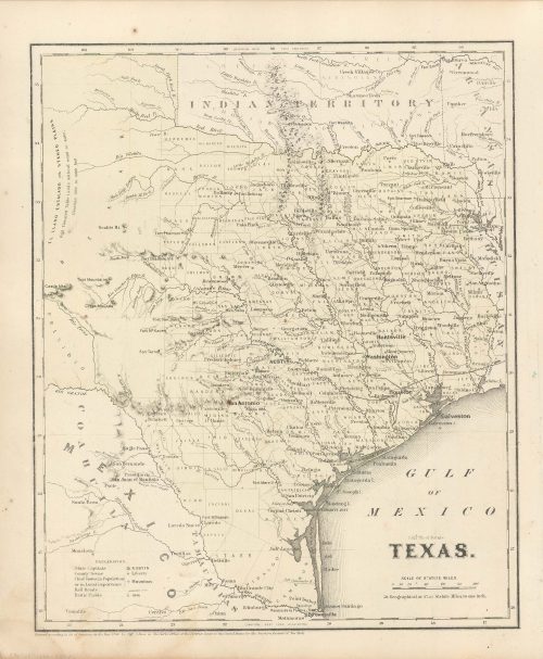
Colton’s 1860 Map of Texas
$
150.00
Only 1 in Stock! Order Now!
Add to cart
Details
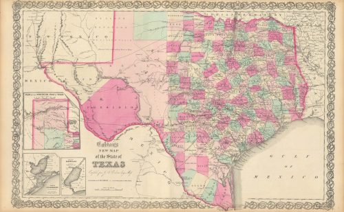
Colton’s 1865 New Map of the State of Texas
$
575.00
Only 1 in Stock! Order Now!
Add to cart
Details
Previous
1
2
3
…
19
Next
Page load link
Go to Top