Skip to content
FREE SHIPPING ON ORDERS OVER $100
Facebook
Instagram
Twitter
Contact Us
Checkout
20 Item(s)
-
$
1,830.00
Counties of Platt, Champaign, and Vermillion, Illinois
1 x
$
75.00
Counties of Erie, Crawford & Venango (Pennsylvania)
1 x
$
50.00
County Map of the State of New Jersey
1 x
$
55.00
Plan Of Boston
1 x
$
165.00
Standard Map of Nevada
1 x
$
55.00
Outline Plan of Monroe County, Mich.
1 x
$
75.00
Sesquicentennial Map of Texas 1836-1986 (Texas Revolution 1835-1836)
2 x
$
50.00
Civil War Atlas: Plate 147; Parts of Misissippi, Alabama, Georgia and Florida
1 x
$
275.00
Gulf of Venezuela, Peninsula de Guajira, Castilletes Anchorage and Approaches
1 x
$
65.00
European Russia
1 x
$
70.00
Matmata, Tunisia
1 x
$
45.00
Massachusetts, Rhode Island and Connecticut, the environs of Boston
1 x
$
120.00
Counties of Northampton, Carbon, Monroe, and Lehigh (Pennsylvania)
1 x
$
55.00
Hillsborough Bridge P.O. (New Hampshire)
1 x
$
50.00
Plan of Boston
1 x
$
225.00
Counties of Clearfield, Cambria and Blair (Pennsylvania)
1 x
$
55.00
Sesquicentennial Map of Texas 1836-1986 (Texas Revolution 1835-1836)
2 x
$
125.00
Massachusetts with insets of Boston & Boston Harbor
1 x
$
45.00
View Cart
Checkout
Search for:
Search for:
Home
Browse All
Christmas & Holiday Gift Ideas for Map & Print Lovers
Ancient Maps
Browse All
Ancient China
Ancient Egypt
Ancient Greece
Ancient India
Ancient Israel
Original, Antique Maps
Browse All
Browse by Location
City & County Maps
Framed Maps
Rare Maps
Military Maps
U.S. Coastal Survey Maps
General Land Office
Old Map Reproductions
Browse All
U.S. City Bird’s Eye Views
Manuscript Maps
War Maps
Old World Maps
Browse All
Original
Giclée Reproductions
Vintage Prints
Browse All
By Subject
Birds
Botanicals
Fish
More…
By Antique Print Makers
John James Audobon
Picturesque America
More…
Vintage Posters
Collecting Posters
Browse All
Original
Lithograph Reproductions
Giclée Reproductions
Replogle Globes
Browse All
Desk Models
Floor Models
Illuminated
4.7″
12″
16″
20
32
Books
Browse All
Books with Maps
Atlases
Reference Books
Historic Colorado Photos
Browse All
Boulder
Denver
Colorado Ski Towns
Colorado Art
Browse All
Kirsten Bingham
John Carlson
Steve Lowtwait
Penny Pearson
Puzzles
Vintage Maps
Old Map Reproductions
Vintage Prints
Custom Framing
Collector’s Guide
Time Charts of Historical Cartography
Antiquity 600 BC to 300 AD
Middle Ages 400 AD to 1400 AD
Renaissance 1470 AD to 1700 AD
History of Print Making
Wood Block
Line Engraving
Etching
Mezzotint Engraving
Stipple Engraving
Aquatint Engravings
Lithographs
Color Prints
General
What Is Meant By The Term “Antique Map”?
Condition of Antique Maps
Sizes of Antique Maps
Coloring of Antique Maps
Glossary of Terms
Factors Affecting the Value of Maps
What Should I Collect?
What Should I Pay?
The Care of Maps & Prints
How to Detect Reproductions?
About Us
Request Or Sell an Item
Request an Item
Sell an Item
Search for:
Bird's Eye View Maps
Invalid Image Size
Default sorting
Sort by popularity
Sort by latest
Sort by price: low to high
Sort by price: high to low
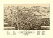
Butte, Montana: 1884
$
30.00
Add to cart
Details
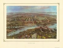
Central Park: 1865
$
30.00
Add to cart
Details
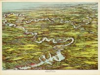
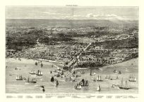
Charles River, Massachusetts
$
30.00
Add to cart
Details
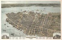
Charleston: 1872
$
30.00
Add to cart
Details
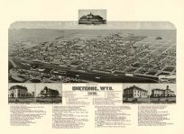
Cheyenne, Wyoming: 1882
$
30.00
Add to cart
Details
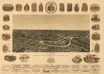
Chicago as it was before the Great Fire
$
30.00
Add to cart
Details
Chicago in the Early Days 1779-1857
$
30.00
Add to cart
Details
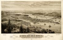
City of Olympia, Washington
$
30.00
Add to cart
Details
City of Washington: 1834
$
30.00
Add to cart
Details
Dallas, Texas 1892
$
30.00
Add to cart
Details
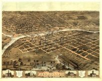
Des Moines, Iowa 1868
$
30.00
Add to cart
Details
Encampment of First Brigade, Augusta, Maine
$
30.00
Add to cart
Details
Previous
1
…
72
73
74
…
79
Next
Page load link
Go to Top