- You cannot add another "Mile High Lakes Quadrangle, Colorado" to your cart. View cart
 |
||
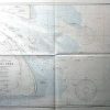
Approaches to the Yangtze River
Out of stock
This coastal survey was made in March of 1944 by the U.S. Hydrographic Office. Approaches to the Yangtze River are illustrated on this map. Details include the names of important cities, depth readings, occasional descriptions of the area, and illustrations where the coast is heavily wooded. A chart converts feet to meters,an explaination of the chinese system of buoys is given,as well as information on the variation of the tide.
Size: 40 x 28 inches
Condition: Excellent
Map Maker: U.S. Hydrographic Office
Coloring: Black and White (Some Machine Color)
Year: 1944
Condition: Excellent
Map Maker: U.S. Hydrographic Office
Coloring: Black and White (Some Machine Color)
Year: 1944
Out of stock