 |
||
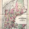
Map of New England
Out of stock
This hand colored map is from H.F.Wallings Atlas of the State of New Hampshire, printed in 1877. The states comprising New England are illustrated on this bright pastel map. Details include railroads, city and state names,identification of important buildings and geographical features such as lakes and rivers. This local map would make a great gift for a resident of the area. ‘
Size: 16 x 22 inches
Condition: Very Good-light water stain in border
Map Maker: H.F. Walling
Coloring: Hand Colored
Year: 1877
Condition: Very Good-light water stain in border
Map Maker: H.F. Walling
Coloring: Hand Colored
Year: 1877
Out of stock