 |
||
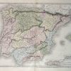
Map of Spain and Portugal
Out of stock
This hand-colored, steel-engraved map is from Blacks General Atlas printed in 1844. This is a beautiful map showing Spain and Portugal. Details, exceptional for a map from this time, include the names of regions, countries, and important cities, mountain ranges, rivers, lakes, and major roads.An inset at a greater scale than the main map that illustrates Gibraltar.
Size: 19.5 x 15 inches
Condition: Excellent
Map Maker: Adam and Charles Black
Coloring: Hand Coloring
Year: 1844
Condition: Excellent
Map Maker: Adam and Charles Black
Coloring: Hand Coloring
Year: 1844
Out of stock