Skip to content
FREE SHIPPING ON ORDERS OVER $100
Facebook
Instagram
Twitter
Contact Us
Checkout
41 Item(s)
-
$
4,452.00
Counties of Clinton & Centre (Pennsylvania)
1 x
$
55.00
Commemorative Map of the Republic of Texas
2 x
$
50.00
Turkey Buzzard
1 x
$
300.00
Outline Plan of Monroe County, Mich.
1 x
$
75.00
Counties of Jefferson, Clarion, Indiana, and Armstrong (Pennsylvania)
1 x
$
55.00
Counties of Wayne and Pike (Pennsylvania)
1 x
$
55.00
Counties of St. Clair, Monroe, Randolph, Perry, and Washington, Illinois
1 x
$
75.00
Counties of Madison, Bond, and Clinton, Illinois
1 x
$
75.00
Counties of Allegheny, Washington, and Greene (Pennsylvania)
1 x
$
55.00
Counties of Clearfield, Cambria and Blair (Pennsylvania)
1 x
$
55.00
Revolutionary War Map Showing Eastern New Jersey and Western Pennsylvania to Elk Head, Maryland
1 x
$
135.00
Best of the Badmen
1 x
$
100.00
European Russia
1 x
$
70.00
Revolutionary War Map of the Country which was the Scene of the Operations of the Northern Army Including the Wilderness through which General Arnold marched to Attack Quebec
1 x
$
175.00
Counties of Platt, Champaign, and Vermillion, Illinois
1 x
$
75.00
Red Eyed Vireo
1 x
$
150.00
Counties of Northampton, Carbon, Monroe, and Lehigh (Pennsylvania)
1 x
$
55.00
The Beatles, Stern" Magazine Set"
1 x
$
1,000.00
Sesquicentennial Map of Texas 1836-1986 (Texas Revolution 1835-1836)
1 x
$
125.00
Mile High Lakes Quadrangle, Colorado
1 x
$
35.00
Gulf of Venezuela, Peninsula de Guajira, Castilletes Anchorage and Approaches
1 x
$
65.00
Hillsborough Bridge P.O. (New Hampshire)
1 x
$
50.00
Ancient Britain II
1 x
$
125.00
County Map of the State of New Jersey
1 x
$
55.00
Counties of Warren, McKean, Potter, Forest, Elk and Cameron (Pennsylvania)
1 x
$
55.00
Bally
1 x
$
180.00
Geographie du Moyen Age Principalement (geography of the middle ages)
1 x
$
50.00
Counties of Fayette, Effingham, Clay, and Marion, Illinois
1 x
$
75.00
West Indies, Puerto Rico - South Coast, Jobos Harbor and Rincon Bay
1 x
$
60.00
I Love Texas 1000 piece Puzzle
1 x
$
25.00
Massachusetts-Provincetown Sheet
1 x
$
140.00
Sesquicentennial Map of Texas 1836-1986 (Texas Revolution 1835-1836)
3 x
$
50.00
Climatological Map of Pennsylvania Showing the Average Temperture & Amount of Rainfall
1 x
$
32.00
Civil War Atlas: Plate 108; Fort Jeb. Stuart K; Mobile Defenses Lunette D; Mouton; G.H. and I.
1 x
$
60.00
Counties of Erie, Crawford & Venango (Pennsylvania)
1 x
$
50.00
Yukon and Forty Mile Creek, Alaska, at the Crossing of the 141st Meridian
1 x
$
45.00
Purple Martin
1 x
$
250.00
Noddy Tern
1 x
$
165.00
View Cart
Checkout
Search for:
Search for:
Home
Browse All
Christmas & Holiday Gift Ideas for Map & Print Lovers
Ancient Maps
Browse All
Ancient China
Ancient Egypt
Ancient Greece
Ancient India
Ancient Israel
Original, Antique Maps
Browse All
Browse by Location
City & County Maps
Framed Maps
Rare Maps
Military Maps
U.S. Coastal Survey Maps
General Land Office
Old Map Reproductions
Browse All
U.S. City Bird’s Eye Views
Manuscript Maps
War Maps
Old World Maps
Browse All
Original
Giclée Reproductions
Vintage Prints
Browse All
By Subject
Birds
Botanicals
Fish
More…
By Antique Print Makers
John James Audobon
Picturesque America
More…
Vintage Posters
Collecting Posters
Browse All
Original
Lithograph Reproductions
Giclée Reproductions
Replogle Globes
Browse All
Desk Models
Floor Models
Illuminated
4.7″
12″
16″
20
32
Books
Browse All
Books with Maps
Atlases
Reference Books
Historic Colorado Photos
Browse All
Boulder
Denver
Colorado Ski Towns
Colorado Art
Browse All
Kirsten Bingham
John Carlson
Steve Lowtwait
Penny Pearson
Puzzles
Vintage Maps
Old Map Reproductions
Vintage Prints
Custom Framing
Collector’s Guide
Time Charts of Historical Cartography
Antiquity 600 BC to 300 AD
Middle Ages 400 AD to 1400 AD
Renaissance 1470 AD to 1700 AD
History of Print Making
Wood Block
Line Engraving
Etching
Mezzotint Engraving
Stipple Engraving
Aquatint Engravings
Lithographs
Color Prints
General
What Is Meant By The Term “Antique Map”?
Condition of Antique Maps
Sizes of Antique Maps
Coloring of Antique Maps
Glossary of Terms
Factors Affecting the Value of Maps
What Should I Collect?
What Should I Pay?
The Care of Maps & Prints
How to Detect Reproductions?
About Us
Request Or Sell an Item
Request an Item
Sell an Item
Search for:
Revolutionary War
You cannot add another "Revolutionary War Map of the Country which was the Scene of the Operations of the Northern Army Including the Wilderness through which General Arnold marched to Attack Quebec" to your cart.
View cart
Default sorting
Sort by popularity
Sort by latest
Sort by price: low to high
Sort by price: high to low
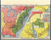
A8 Revolutionary War 1775-1783
$
100.00
Only 1 in Stock! Order Now!
Add to cart
Details
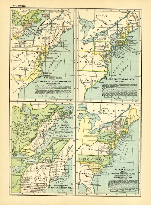
King James Grants to the Plymouth and London Companies 1606, 1609 and 1620. Early Colonial Grants 1620 to 1681. French and Inidan War, 1756 to 1763. The United States 1783 showing the Thirteen Original States, During the Period of the Revolutionary War.
$
65.00
Add to cart
Details
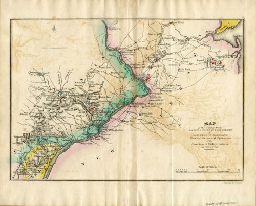
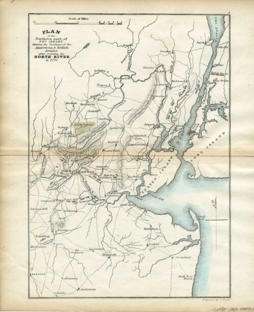
Revolutionary War Map of the Country from Raritan River in East Jersey to Elk Head in Maryland Showing the several Operations of the American and British Armies in1776 and 1777, (1835) Elk Head, Maryland
$
155.00
Only 1 in Stock! Order Now!
Add to cart
Details
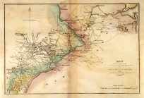
Revolutionary War Map of the Country from Raritan River in East Jersey to Elk Head in Maryland Showing the several Operations of the American and British Armies in1776 and 1777, (1850) Elk Head, Maryland (Copy)
$
155.00
Only 1 in Stock! Order Now!
Add to cart
Details
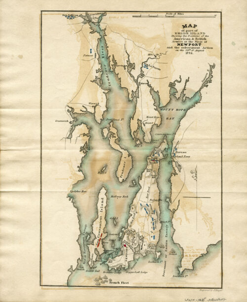
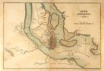
Revolutionary War Map of part of Rhode Island Shewing the Positions of the American and British Armies at the Siege of Newport and the subsequent Action on the 29th of August 1778, (1835)
$
165.00
Only 1 in Stock! Order Now!
Add to cart
Details
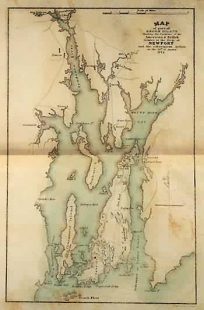
Revolutionary War Map of part of Rhode Island showing the Positions of the American and British Armies at the Siege of Newport and the subsequent Action on the 29th of August 1773(1850)
$
165.00
Only 1 in Stock! Order Now!
Add to cart
Details
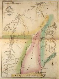
Revolutionary War Map of the Country which was the Scene of Operations of the Northern Army Including the Wilderness Through which Gen. Arnold marched to attack Quebec, 1775, (1835)
$
155.00
Only 1 in Stock! Order Now!
Add to cart
Details
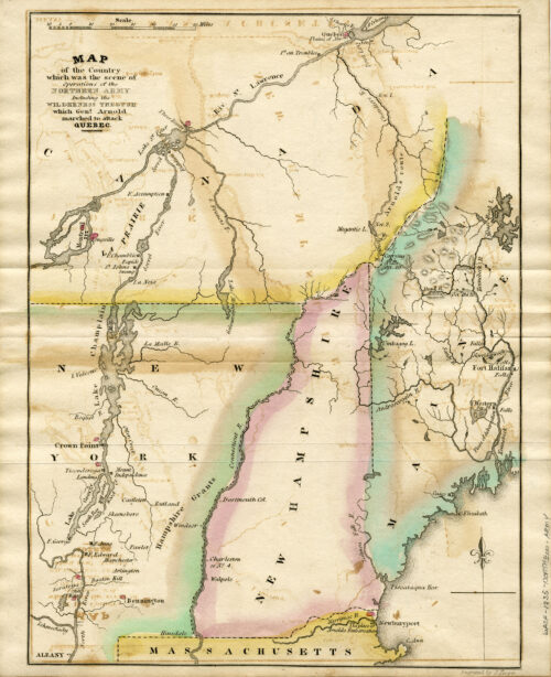
Revolutionary War Map of the Country which was the Scene of the Operations of the Northern Army Including the Wilderness through which General Arnold marched to Attack Quebec
$
175.00
Only 1 in Stock! Order Now!
Add to cart
Details
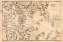
Revolutionary War Map Showing Boston
$
195.00
Only 1 in Stock! Order Now!
Add to cart
Details
Revolutionary War Map Showing Charleston, South Carolina
$
155.00
Only 1 in Stock! Order Now!
Add to cart
Details
Revolutionary War Map Showing Eastern New Jersey and Western Pennsylvania to Elk Head, Maryland
$
135.00
Only 1 in Stock! Order Now!
Add to cart
Details
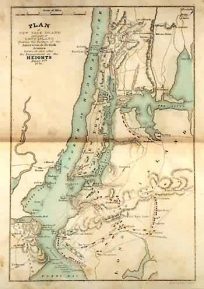
Revolutionary War Map Showing New York City
$
175.00
Only 1 in Stock! Order Now!
Add to cart
Details
1
2
Next
Page load link
Go to Top