Skip to content
FREE SHIPPING ON ORDERS OVER $100
Facebook
Instagram
Twitter
Contact Us
Checkout
1 Item(s)
-
$
200.00
Johnsons Eastern and Western Hemisphere
1 x
$
200.00
View Cart
Checkout
Search for:
Search for:
Home
Browse All
Christmas & Holiday Gift Ideas for Map & Print Lovers
Ancient Maps
Browse All
Ancient China
Ancient Egypt
Ancient Greece
Ancient India
Ancient Israel
Original, Antique Maps
Browse All
Browse by Location
City & County Maps
Framed Maps
Rare Maps
Military Maps
U.S. Coastal Survey Maps
General Land Office
Old Map Reproductions
Browse All
U.S. City Bird’s Eye Views
Manuscript Maps
War Maps
Old World Maps
Browse All
Original
Giclée Reproductions
Vintage Prints
Browse All
By Subject
Birds
Botanicals
Fish
More…
By Antique Print Makers
John James Audobon
Picturesque America
More…
Vintage Posters
Collecting Posters
Browse All
Original
Lithograph Reproductions
Giclée Reproductions
Replogle Globes
Browse All
Desk Models
Floor Models
Illuminated
4.7″
12″
16″
20
32
Books
Browse All
Books with Maps
Atlases
Reference Books
Historic Colorado Photos
Browse All
Boulder
Denver
Colorado Ski Towns
Colorado Art
Browse All
Kirsten Bingham
John Carlson
Steve Lowtwait
Penny Pearson
Puzzles
Vintage Maps
Old Map Reproductions
Vintage Prints
Custom Framing
Collector’s Guide
Time Charts of Historical Cartography
Antiquity 600 BC to 300 AD
Middle Ages 400 AD to 1400 AD
Renaissance 1470 AD to 1700 AD
History of Print Making
Wood Block
Line Engraving
Etching
Mezzotint Engraving
Stipple Engraving
Aquatint Engravings
Lithographs
Color Prints
General
What Is Meant By The Term “Antique Map”?
Condition of Antique Maps
Sizes of Antique Maps
Coloring of Antique Maps
Glossary of Terms
Factors Affecting the Value of Maps
What Should I Collect?
What Should I Pay?
The Care of Maps & Prints
How to Detect Reproductions?
About Us
Request Or Sell an Item
Request an Item
Sell an Item
Search for:
World
Invalid Image Size
Default sorting
Sort by popularity
Sort by latest
Sort by price: low to high
Sort by price: high to low
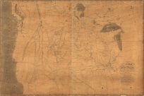
A map of part of the continent of North America : between the 35th and 51st degrees of north latitude, and extending from 890 degrees of west longitude to the Pacific Ocean / compiled from the authorities of the best informed travellers by M. Lewis
$
30.00
Add to cart
Details
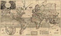
A New & Correct Map of the Whole World
$
30.00
Add to cart
Details
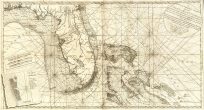
A New and Correct Chart of the Coast of East Florida
$
30.00
Add to cart
Details
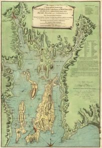
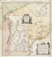
A Topographical Chart of the Bay of Narraganset in the Province of New England
$
30.00
Add to cart
Details
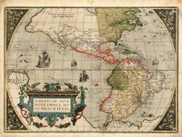
America sive India Nova [America, or New India]
$
30.00
Add to cart
Details
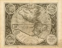
America Sive Novus Orbis Respectu Europaeorum Inferior Globi Terrestris Pars
$
30.00
Add to cart
Details
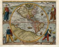
Americae, Sive Novi Orbis, Nova Descriptio [America, or the New World, a New Description]
$
30.00
Add to cart
Details
An accurate map of His Majesty’s province of New-Hampshire in New England
$
30.00
Add to cart
Details
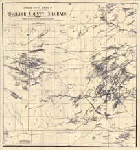
Approved Mineral Surveys of Boulder County
$
30.00
Add to cart
Details
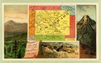
Arbuckles’ Coffee Card of Colorado (Reproduction)
$
30.00
Add to cart
Details
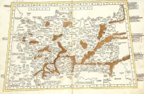
Asie maioris tabule decem quarum prima : prima Asie tabula
$
30.00
Add to cart
Details
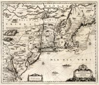
Belgii Novi, Angliae Novae et Partis Virginiae
$
30.00
Add to cart
Details
1
2
…
11
Next
Page load link
Go to Top